Download Florida Nautical Charts GPS HD for PC
Published by Flytomap
- License: £9.99
- Category: Navigation
- Last Updated: 2022-03-19
- File size: 128.72 MB
- Compatibility: Requires Windows XP, Vista, 7, 8, Windows 10 and Windows 11
Download ⇩
Published by Flytomap
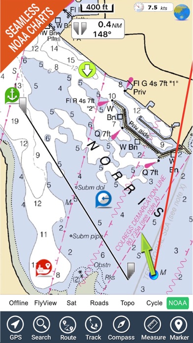
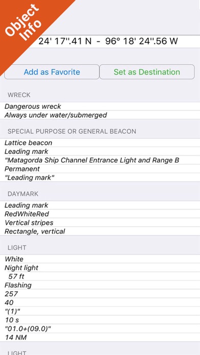

WindowsDen the one-stop for Navigation Pc apps presents you Florida Nautical Charts GPS HD by Flytomap -- Flytomap is a valid and interesting alternative, Benetti Yachts Featured in : On the Deck Florida, Bahamas and North Cuba coverage resident in the app. It works WITHOUT mobile coverage. • Worldwide Marine and Outdoor Maps available, thanks to viewer. flytomap. com • Worldwide Satellite images overlay on charts • Worldwide Terrain features overlay on charts, thanks to Open Street Map, Open Cycle Map, Bing, Earth,Topo Chart and GMap • Local Marine Weather forecast • Available on iWatch Now with NOAA raster charts seamless with continuous updates from the official Government server Get this chart for your Lowrance, Simrad and B&G at a very competitive price Use to Explore: √ Latitudes and Longitudes to go to your favorite places √ Search your Favorite points directly √ Zoom, Rotate and Pan fast just by a finger touch √ Quick Object information just tapping, thanks to vector technology √ GPS Heading Vector Towards the direction movement √ Distance Measurement Tool to easily calculate the distance from one location to another √ Route planning, unlimited Waypoints - Insert the target/destination and see in real time your speed, distance and bearing √ Magnified Lens for all info √ Unlimited Tracks, Markers, Geo-tagged photos, records and share via email, visible on Google, Flytomap Viewer, KMZ format - Store your track without the need of cellular data or mobile signal √ Select Depth Contours √ a la carte menu √ MOB - Man Over Board √ Quick WP - allows you to instantly record your position and show distance and bearing √ iOS background mode - Flytomap works in background as well, you can swap with another app and receive/make calls send sms while track recording. √ Optimized battery usage • Continuous update of all info (including reviews from the deck) about : • Marinas • Anchorages • Hazards • Local Knowledge √ Local Marine Weather forecast at a quick tap provide you: • Day max and min temperature - Current temperature • Significant wave height, Swell height, Swell period, Swell direction • Tide data • Sea temperature • Wind Speed and direction • Weather description • Precipitation & Humidity • Visibility • Pressure • Cloud cover in percentage • Wind chill/Feels like Temperature • Water Temperature • Dew Point Temperature • Heat Index Temperature √ And so much more to come - It’s the only app you will ever need.. We hope you enjoyed learning about Florida Nautical Charts GPS HD. Download it today for £9.99. It's only 128.72 MB. Follow our tutorials below to get Florida Nautical Charts GPS HD version 5.9.2 working on Windows 10 and 11.
| SN. | App | Download | Developer |
|---|---|---|---|
| 1. |
 i-Boating: USA - GPS
Nautical Charts |
Download ↲ | Bist LLC |
| 2. |
i-Boating: Australia GPS Nautical Charts |
Download ↲ | Bist LLC |
| 3. |
GPS Maps Navigation
|
Download ↲ | Cidade |
| 4. |
i-Boating : Marine Navigation Charts & Lake Maps GPS |
Download ↲ | Bist LLC |
| 5. |
i-Boating:Marine Navigation Maps & Nautical Charts |
Download ↲ | Bist LLC |
OR
Alternatively, download Florida Nautical Charts GPS HD APK for PC (Emulator) below:
| Download | Developer | Rating | Reviews |
|---|---|---|---|
|
i-Boating:Marine Navigation Download Apk for PC ↲ |
Gps Nautical Charts | 4.7 | 11,308 |
|
i-Boating:Marine Navigation GET ↲ |
Gps Nautical Charts | 4.7 | 11,308 |
|
Marine Ways - Nautical Charts GET ↲ |
Kernalite | 4.5 | 2,066 |
|
Wavve Boating: Easy Marine GPS GET ↲ |
Wavve Boating | 4.4 | 854 |
|
C-MAP - Marine Charts
GET ↲ |
Navico Norway AS | 3.9 | 11,309 |
|
Navionics® Boating
GET ↲ |
Garmin Italy Technologies srl |
3.8 | 38,818 |
Follow Tutorial below to use Florida Nautical Charts GPS HD APK on PC:
Get Florida Nautical Charts GPS HD on Apple Mac
| Download | Developer | Rating | Score |
|---|---|---|---|
| Download Mac App | Flytomap | 0 | 0 |