WindowsDen the one-stop for Travel Pc apps presents you WeTrek – Trail, Hike & Cycling by Ubicarta -- IGNrando’ is a French collaborative platform offering curated data and services related to outdoor activities.
RICH DATA OFFER
• Tens of thousands of available routes accross Metropolitan and Overseas France
• Choose the activity, difficulty and length to find routes around you or near any other place
• Download routes or mark them as favorites
MAPS IN FREE ACCESS (with internet connection)
• Plan IGN: most updated map, suitable for all activities
• Aerial photos (IGN)
• OpenStreetMap Outdoors: world map with hiking routes & contour lines
• OpenCycleMap: world map with cycling routes & contour lines
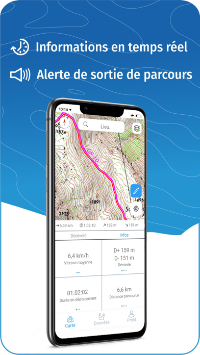
GPS GUIDING ALONG ROUTES
• See your progression on the map and on the elevation profile
• Get alerted if you exit the route
• Get notified of upcoming POIs or route info points (available soon)
GPS TRACKING AND DATA CREATION
• Record your own routes using GPS
• Create routes on-device (vertex by vertex)
• Quickly create routes with pedestrian and vehicle routing (automatically follows roads and paths) - available with IGN Maps subscription
• Create Points of interest
• Export Routes or Points to save them locally (Files app) or share them
• Send your routes to ignrando. fr for backup or to publish them
OFFLINE USE
• The GPS keeps working even without internet: see your position on the map, use GPS guiding and record routes
• Downloaded routes: descriptions, photos and guiding remain accessible
• Downloaded maps (with subscription)
USEFUL TIP: Enabling Airplane Mode or disabling Mobile Data improves battery life, without affecting the Location Services (GPS)
IGN MAPS SUBSCRIPTION
• View & download the following maps:
∙ Free version maps
∙ IGN maps (various scales)
∙ IGN 1:25k topo maps (Top 25): the famous French topographical maps available at all zoom levels
∙ 1950 IGN maps
∙ Military maps (1820-1866)
∙ ICAO aeronautical charts
∙ Slopes > 30° (transparent layer, useful for winter activites)
∙ Cadastral parcels layer
∙ Roads & paths layer
• More zoom levels for all maps
• Pedestrian and vehicle routing in route creation
IGNrando' store subscription
• Linked to IGNrando' account
• No automatic renewal
• Can be used on 3 devices at the same time
App Store subscription
• Linked to Apple account
• Automatic renewal unless cancelled at least 24 hours before the end of the current period
• Auto-renewal may be turned off by going to the user's Account Settings after purchase
• Any unused portion of a free trial period will be forfeited when the user purchases a subscription
WARNING: Ubicarta or IGN cannot refund subscriptions purchased on the App Store, only Apple can, at its sole discretion
ONLINE HELP (french only)
https://ignrando. ubicarta. com/help
FAQ (frequently asked questions - french only)
https://ignrando. ubicarta.. We hope you enjoyed learning about WeTrek – Trail, Hike & Cycling. Download it today for Free. It's only 54.52 MB. Follow our tutorials below to get WeTrek version 1.84 working on Windows 10 and 11.


 Hiking Map
 Hiken
Hiken